
Kernours topographic map
Interactive map
Click on the map to display elevation.
About this map
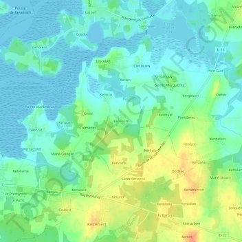
Name: Kernours topographic map, elevation, terrain.
Average elevation: 13 m
Minimum elevation: -2 m
Maximum elevation: 38 m
Other topographic maps
Click on a map to view its topography, its elevation and its terrain.
Kerdonnerch
France > Bretagne > Morbihan > Belz
Kerdonnerch, Belz, Lorient, Morbihan, Bretagne, France métropolitaine, 56550, France
Average elevation: 14 m
Le Couëdic
France > Bretagne > Morbihan > Belz
Le Couëdic, Belz, Lorient, Morbihan, Bretagne, France métropolitaine, 56550, France
Average elevation: 10 m