
La Roche du Page topographic map
Interactive map
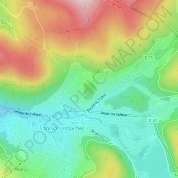
Click on the map to display elevation.
About this map
Name: La Roche du Page topographic map, elevation, terrain.
Average elevation: 828 m
Minimum elevation: 699 m
Maximum elevation: 1,033 m
Other topographic maps
Click on a map to view its topography, its elevation and its terrain.
Les Plombes
France > Grand Est > Vosges > Xonrupt-Longemer
Les Plombes, Xonrupt-Longemer, Saint-Dié-des-Vosges, Vosges, Grand Est, France métropolitaine, 88400, France
Average elevation: 882 m
Ferme de Vologne
France > Grand Est > Vosges > Xonrupt-Longemer > Ferme de Vologne
Ferme de Vologne, Xonrupt-Longemer, Saint-Dié-des-Vosges, Vosges, Grand Est, France métropolitaine, 88400, France
Average elevation: 806 m
Refuge du Sotré
France > Grand Est > Vosges > Xonrupt-Longemer > La Schlucht
Refuge du Sotré, Route des Crêtes, La Schlucht, Xonrupt-Longemer, Saint-Dié-des-Vosges, Vosges, Grand Est, France métropolitaine, 88400, France
Average elevation: 1,137 m
Retournemer
France > Grand Est > Vosges > Xonrupt-Longemer
Retournemer, Xonrupt-Longemer, Saint-Dié-des-Vosges, Vosges, Grand Est, France métropolitaine, 88400, France
Average elevation: 1,009 m