
Thank you for supporting this site ❤️
Make a donation
Make a donation
McLouth topographic map
Click on the map to display elevation.
Thank you for supporting this site ❤️
Make a donation
Make a donation
About this map
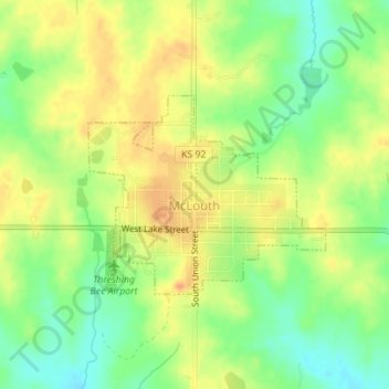
Name: McLouth topographic map, elevation, terrain.
Location: McLouth, Jefferson County, Kansas, United States (39.18969 -95.21782 39.20347 -95.19653)
Average elevation: 350 m
Minimum elevation: 327 m
Maximum elevation: 369 m
Thank you for supporting this site ❤️
Make a donation
Make a donation
Other topographic maps
Click on a map to view its topography, its elevation and its terrain.
Valley Falls
United States > Kansas > Jefferson County > Valley Falls > Valley Falls
Average elevation: 296 m