
Tarn Hows topographic map
Click on the map to display elevation.
About this map
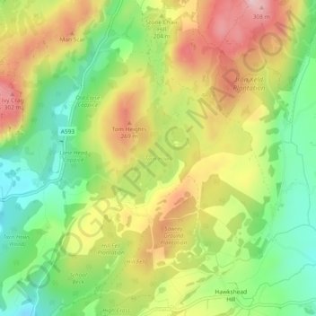
Name: Tarn Hows topographic map, elevation, terrain.
Average elevation: 187 m
Minimum elevation: 74 m
Maximum elevation: 315 m
Other topographic maps
Click on a map to view its topography, its elevation and its terrain.
Old Man of Coniston
United Kingdom > England > Westmorland and Furness > Coniston
The first section rising steeply from Coniston is a metalled road, maintained partly to provide access to the quarry. This leads to a car park at an altitude of 740 ft (230 m), a popular starting point for climbs. Beyond here motor vehicles are prohibited, but the track continues to its summit at 2,000 ft (610…
Average elevation: 501 m