
Make a donation
Jengish Chokusu topographic map
Click on the map to display elevation.
Make a donation
Jengish Chokusu
Jengish Chokusu is the highest mountain in Kyrgyzstan and Earth's highest mountain north of 39°N. It is considered the most northerly 7,000-metre mountain in the world by geologists; the actual rock summit of Khan Tengri, the Tian Shan's second-highest peak, is 6,995m above sea level, though a thick layer of ice adds another 15m to its altitude, such that mountaineers consider it a 7,000m peak.
Make a donation
About this map
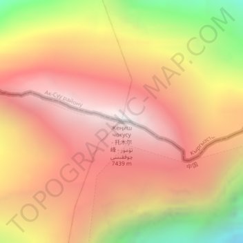
Name: Jengish Chokusu topographic map, elevation, terrain.
Location: Jengish Chokusu, Ak-Suu District, Issyk-Kul Region, Kyrgyzstan (42.03497 80.12946 42.03507 80.12956)
Average elevation: 6,664 m
Minimum elevation: 5,439 m
Maximum elevation: 7,456 m
Make a donation
Other topographic maps
Click on a map to view its topography, its elevation and its terrain.
Ala-Köl
Kyrgyzstan > Issyk-Kul Region > Ak-Suu District
Ala-Köl (Kyrgyz: Ала-Көл, also Алакөл, Russian: Ала-Куль, romanized: Ala-Kul) is a rock-dammed lake in the Terskey Alatau mountain range in the Ak-Suu District of the Issyk-Kul Region in Kyrgyzstan. It lies at an altitude of 3,532 m (11,588 ft). It is 2.8 km (1.7 mi) long and 600–700 m…
Average elevation: 3,703 m