
Thank you for supporting this site ❤️
Make a donation
Make a donation
Cabo Rojo topographic map
Click on the map to display elevation.
Thank you for supporting this site ❤️
Make a donation
Make a donation
About this map
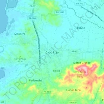
Name: Cabo Rojo topographic map, elevation, terrain.
Location: Cabo Rojo, Puerto Rico, 00623-0910, United States (18.04702 -67.18591 18.12702 -67.10591)
Average elevation: 45 m
Minimum elevation: 0 m
Maximum elevation: 247 m
Thank you for supporting this site ❤️
Make a donation
Make a donation
Other topographic maps
Click on a map to view its topography, its elevation and its terrain.