
Thank you for supporting this site ❤️
Make a donation
Make a donation
Chez Rouget topographic map
Click on the map to display elevation.
Thank you for supporting this site ❤️
Make a donation
Make a donation
About this map
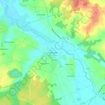
Name: Chez Rouget topographic map, elevation, terrain.
Average elevation: 88 m
Minimum elevation: 66 m
Maximum elevation: 129 m
Thank you for supporting this site ❤️
Make a donation
Make a donation
Other topographic maps
Click on a map to view its topography, its elevation and its terrain.
La Rochette
France > Nouvelle-Aquitaine > Charente > La Rochette
Le relief est celui d'un bas plateau d'une altitude moyenne de 90 m descendant en pente douce vers la large vallée de la Tardoire qui traverse la commune du sud-est au nord-ouest. Le point culminant de la commune est à une altitude de 115 m, situé au nord sur la D.45 en limite avec Sainte-Colombe. Au…
Average elevation: 88 m