
Make a donation
Bridgewater topographic map
Click on the map to display elevation.
Make a donation
Bridgewater
According to the United States Census Bureau, the town has a total area of 2.52 sq mi (6.5 km2), nearly all of it being land. Most of the town is located within a bend of the North River. Floods have wrecked the town occasionally. The northern areas are partly shielded from flooding with an Army Corps of Engineers dam. The wooded monadnock called Round Hill (elevation approx. 1750 feet) dominates the town's western skyline.
Make a donation
About this map
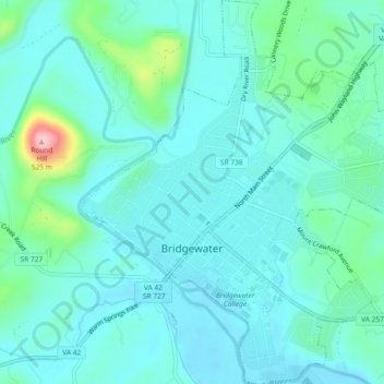
Name: Bridgewater topographic map, elevation, terrain.
Location: Bridgewater, Rockingham County, Virginia, United States (38.36928 -78.98997 38.40543 -78.94621)
Average elevation: 380 m
Minimum elevation: 351 m
Maximum elevation: 515 m
Make a donation
Other topographic maps
Click on a map to view its topography, its elevation and its terrain.
Harrisonburg/Warm Springs Turnpike Park
United States > Virginia > Rockingham County > Bridgewater
Average elevation: 378 m
Make a donation
Make a donation
Make a donation