
Make a donation
Wausau topographic map
Click on the map to display elevation.
Make a donation
Wausau
According to the United States Census Bureau, the city has a total area of 20.33 square miles (52.7 km2), of which 19.22 square miles (49.8 km2) is land and 1.11 square miles (2.9 km2) is water. The city is located at an altitude of 1,195 feet (364 m). Wausau is close to the center of the northern half of the Western Hemisphere. Just west of Wausau, 45°N meets 90°W (45°N 90°W / 45°N 90°W / 45; -90), which is exactly halfway between the equator and the north pole and a quarter of the way around the world from the prime meridian.
Make a donation
About this map
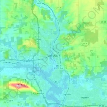
Name: Wausau topographic map, elevation, terrain.
Location: Wausau, Marathon County, Wisconsin, United States (44.91855 -89.76793 45.00644 -89.57292)
Average elevation: 394 m
Minimum elevation: 351 m
Maximum elevation: 585 m
Make a donation
Other topographic maps
Click on a map to view its topography, its elevation and its terrain.
George W Mead State Wildlife Management Area
United States > Wisconsin > Marathon County > Town of Bergen
Average elevation: 343 m
Make a donation
Bypass Channel Wisconsin River
United States > Wisconsin > Marathon County > Wausau
Average elevation: 371 m