
Croissant Poullogoden topographic map
Interactive map
Click on the map to display elevation.
About this map
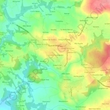
Name: Croissant Poullogoden topographic map, elevation, terrain.
Average elevation: 43 m
Minimum elevation: 2 m
Maximum elevation: 99 m
Other topographic maps
Click on a map to view its topography, its elevation and its terrain.
Neïz Vran
France > Bretagne > Finistère > Saint-Évarzec
Neïz Vran, Saint-Évarzec, Quimper, Finistère, Bretagne, France métropolitaine, 29170, France
Average elevation: 57 m
Kerdélec
France > Bretagne > Finistère > Saint-Évarzec
Kerdélec, Saint-Évarzec, Quimper, Finistère, Bretagne, France métropolitaine, 29170, France
Average elevation: 70 m
Ty Broën
France > Bretagne > Finistère > Saint-Évarzec
Ty Broën, Saint-Évarzec, Quimper, Finistère, Bretagne, France métropolitaine, 29170, France
Average elevation: 55 m