
Thank you for supporting this site ❤️
Make a donation
Make a donation
Paengseong topographic map
Click on the map to display elevation.
Thank you for supporting this site ❤️
Make a donation
Make a donation
About this map
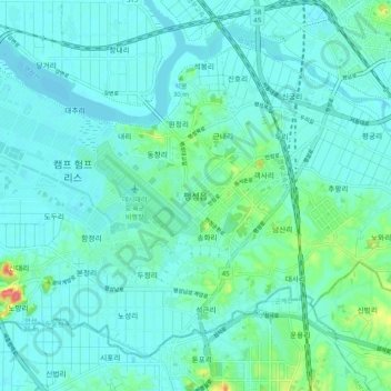
Name: Paengseong topographic map, elevation, terrain.
Location: Paengseong, Pyeongtaek-si, 17982, South Korea (36.92127 127.00395 37.00127 127.08395)
Average elevation: 12 m
Minimum elevation: 2 m
Maximum elevation: 64 m
Thank you for supporting this site ❤️
Make a donation
Make a donation
Other topographic maps
Click on a map to view its topography, its elevation and its terrain.