
Herndon topographic map
Interactive map
Click on the map to display elevation.
About this map
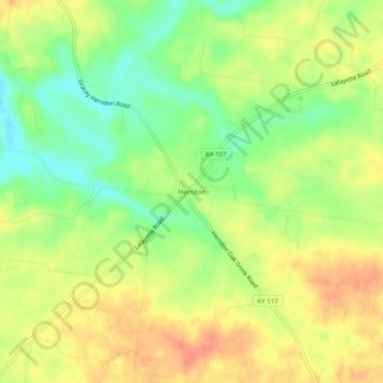
Name: Herndon topographic map, elevation, terrain.
Location: Herndon, Christian County, Kentucky, United States (36.71366 -87.58529 36.75366 -87.54529)
Average elevation: 163 m
Minimum elevation: 138 m
Maximum elevation: 183 m
Other topographic maps
Click on a map to view its topography, its elevation and its terrain.
Hopkinsville
United States > Kentucky > Christian County
Hopkinsville, Christian County, Kentucky, 42240, United States
Average elevation: 171 m
LaFayette
United States > Kentucky > Christian County
LaFayette, Christian County, Kentucky, 42254, United States
Average elevation: 169 m