
Thank you for supporting this site ❤️
Make a donation
Make a donation
Lake Mohegan topographic map
Click on the map to display elevation.
Thank you for supporting this site ❤️
Make a donation
Make a donation
About this map
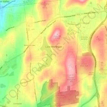
Name: Lake Mohegan topographic map, elevation, terrain.
Average elevation: 140 m
Minimum elevation: 38 m
Maximum elevation: 216 m
Thank you for supporting this site ❤️
Make a donation
Make a donation
Other topographic maps
Click on a map to view its topography, its elevation and its terrain.
Turkey Mountain
United States > New York > Westchester County > Town of Yorktown
Average elevation: 142 m