
Thank you for supporting this site ❤️
Make a donation
Make a donation
Laar topographic map
Click on the map to display elevation.
Thank you for supporting this site ❤️
Make a donation
Make a donation
Laar
Laar ligt in Droog-Haspengouw op een hoogte van 49-81 meter.
Thank you for supporting this site ❤️
Make a donation
Make a donation
About this map
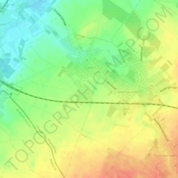
Name: Laar topographic map, elevation, terrain.
Location: Laar, Landen, Leuven, Vlaams-Brabant, Vlaanderen, België (50.75111 5.00335 50.78121 5.03488)
Average elevation: 65 m
Minimum elevation: 40 m
Maximum elevation: 89 m
Thank you for supporting this site ❤️
Make a donation
Make a donation
Other topographic maps
Click on a map to view its topography, its elevation and its terrain.