
Gulja topographic map
Interactive map
Click on the map to display elevation.
About this map
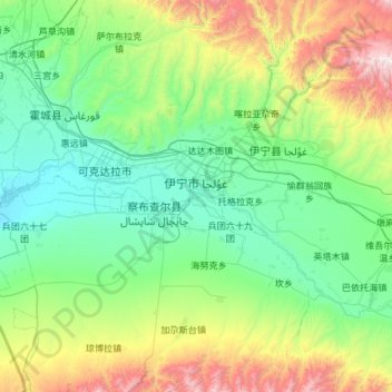
Name: Gulja topographic map, elevation, terrain.
Location: Gulja, Kasachische Autonome Bezirk Ili, Xinjiang, China (43.44477 81.02693 44.30105 81.49591)
Average elevation: 1,035 m
Minimum elevation: 540 m
Maximum elevation: 3,094 m
Other topographic maps
Click on a map to view its topography, its elevation and its terrain.
Tarimbecken
Tarimbecken, 塔中镇, 且末县, 巴音郭楞蒙古自治州, Xinjiang, China
Average elevation: 1,055 m
天山山脉
China > Xinjiang > Aksu Konaxeher
天山山脉, Aksu Konaxeher, Regierungsbezirk Aksu, Xinjiang, China
Average elevation: 6,096 m