
尖山乡 topographic map
Interactive map
Click on the map to display elevation.
About this map
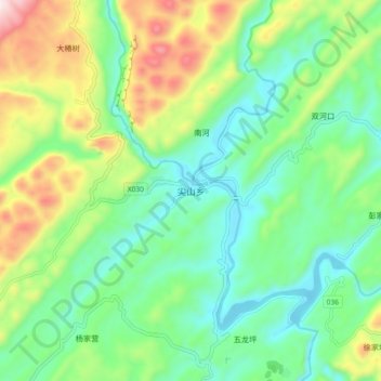
Name: 尖山乡 topographic map, elevation, terrain.
Location: 尖山乡, 咸丰县, 恩施土家族苗族自治州, 湖北省, 445600, 中国 (29.66393 108.95999 29.74393 109.03999)
Average elevation: 691 m
Minimum elevation: 498 m
Maximum elevation: 1,111 m
Other topographic maps
Click on a map to view its topography, its elevation and its terrain.