
Thank you for supporting this site ❤️
Make a donation
Make a donation
Thompson Township topographic map
Click on the map to display elevation.
Thank you for supporting this site ❤️
Make a donation
Make a donation
About this map
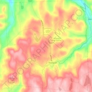
Name: Thompson Township topographic map, elevation, terrain.
Average elevation: 532 m
Minimum elevation: 368 m
Maximum elevation: 646 m
Thank you for supporting this site ❤️
Make a donation
Make a donation
Other topographic maps
Click on a map to view its topography, its elevation and its terrain.
Heart Lake
United States > Pennsylvania > Susquehanna County > Bridgewater Township
Average elevation: 482 m
Thank you for supporting this site ❤️
Make a donation
Make a donation
Lake Erie
United States > Pennsylvania > Susquehanna County > Clifford Township
Average elevation: 517 m
Thank you for supporting this site ❤️
Make a donation
Make a donation
Thank you for supporting this site ❤️
Make a donation
Make a donation