
Thank you for supporting this site ❤️
Make a donation
Make a donation
Castro Marim topographic map
Click on the map to display elevation.
Thank you for supporting this site ❤️
Make a donation
Make a donation
About this map
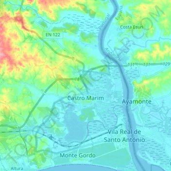
Name: Castro Marim topographic map, elevation, terrain.
Location: Castro Marim, Faro, Algarve, Portugal (37.17287 -7.53934 37.27840 -7.41257)
Average elevation: 22 m
Minimum elevation: -3 m
Maximum elevation: 128 m
Thank you for supporting this site ❤️
Make a donation
Make a donation