
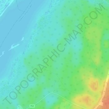
Ободовская Дача topographic map
Interactive map
Click on the map to display elevation.
About this map
Name: Ободовская Дача topographic map, elevation, terrain.
Average elevation: 166 m
Minimum elevation: 154 m
Maximum elevation: 195 m
Other topographic maps
Click on a map to view its topography, its elevation and its terrain.
Старинки
Беларусь > Минская область > Вилейский район > Ильянский сельский Совет
Старинки, Ильянский сельский Совет, Вилейский район, Минская область, Беларусь
Average elevation: 189 m