Make a donation
Peterborough topographic map
Click on the map to display elevation.
Make a donation
Peterborough
The cathedral city of Ely is 24 miles (39 km) east-southeast across the Fens and the university city of Cambridge is 30 miles (48 km) to the southeast. The local topography is flat, and in places, the land lies below sea level.
Make a donation
About this map
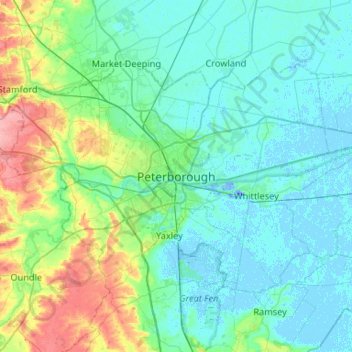
Name: Peterborough topographic map, elevation, terrain.
Average elevation: 17 m
Minimum elevation: -19 m
Maximum elevation: 92 m
Make a donation
Other topographic maps
Click on a map to view its topography, its elevation and its terrain.
Cambridge
United Kingdom > England > Cambridgeshire
The city, like most of the UK, has a maritime climate highly influenced by the Gulf Stream. Located in the driest region of Britain, Cambridge's rainfall averages around 570 mm (22.44 in) per year, around half the national average, The driest recent year was in 2011 with 380.4 mm (14.98 in) of rain at the…
Average elevation: 18 m
Ely
United Kingdom > England > Cambridgeshire
Ely is built on a 23-square-mile (60 km2) Kimmeridge Clay island which, at 85 feet (26 m), is the highest land in the Fens. It was due to this topography that Ely was not waterlogged like the surrounding Fenland, and was an island separated from the mainland. Major rivers including the Witham, Welland, Nene…
Average elevation: 4 m
Cambridge
United Kingdom > England > Cambridgeshire
The city, like most of the UK, has a maritime climate highly influenced by the Gulf Stream. Located in the driest region of Britain, Cambridge's rainfall averages around 570 mm (22.44 in) per year, around half the national average. The driest recent year was in 2011 with 380.4 mm (14.98 in) of rain at the…
Average elevation: 18 m
Make a donation
Kimbolton
United Kingdom > England > Cambridgeshire > Huntingdonshire > Kimbolton
Average elevation: 54 m
Make a donation
Nine Wells
United Kingdom > England > Cambridgeshire > South Cambridgeshire > Great Shelford
Average elevation: 20 m
Cambridge
United Kingdom > England > Cambridgeshire
The city, like most of the UK, has a maritime climate highly influenced by the Gulf Stream. Located in the driest region of Britain, Cambridge's rainfall averages around 570 mm (22.44 in) per year, around half the national average. The driest recent year was in 2011 with 380.4 mm (14.98 in) of rain at the…
Average elevation: 18 m
Brampton
United Kingdom > England > Cambridgeshire > Huntingdonshire > Brampton
Average elevation: 22 m
Make a donation
Westley Waterless
United Kingdom > England > Cambridgeshire > East Cambridgeshire
Average elevation: 92 m
Hinchingbrooke Country Park
United Kingdom > England > Cambridgeshire > Huntingdonshire > Huntingdon > Brampton
Average elevation: 16 m
Make a donation
Bluntisham
United Kingdom > England > Cambridgeshire > Huntingdonshire > Bluntisham
Average elevation: 12 m
Make a donation
Kimbolton
United Kingdom > England > Cambridgeshire > Huntingdonshire > Kimbolton
Average elevation: 54 m
Papworth Everard
United Kingdom > England > Cambridgeshire > South Cambridgeshire
Average elevation: 51 m
Make a donation
Make a donation
Hemingford Grey
United Kingdom > England > Cambridgeshire > Huntingdonshire > Hemingford Grey
Average elevation: 11 m
Abbots Ripton
United Kingdom > England > Cambridgeshire > Huntingdonshire > Abbots Ripton
Average elevation: 38 m
Broughton
United Kingdom > England > Cambridgeshire > Huntingdonshire > Broughton
Average elevation: 31 m
Make a donation
Shingay cum Wendy
United Kingdom > England > Cambridgeshire > South Cambridgeshire > Wendy
Average elevation: 28 m
Cambridge
United Kingdom > England > Cambridgeshire
The city, like most of the UK, has a maritime climate highly influenced by the Gulf Stream. Located in the driest region of Britain, Cambridge's rainfall averages around 570 mm (22.44 in) per year, around half the national average. The driest recent year was in 2011 with 380.4 mm (14.98 in) of rain at the…
Average elevation: 18 m
Make a donation
West Wratting
United Kingdom > England > Cambridgeshire > South Cambridgeshire
Average elevation: 92 m
Make a donation
Make a donation
Make a donation
Make a donation
Make a donation
Cottenham
United Kingdom > England > Cambridgeshire > South Cambridgeshire > Cottenham
Average elevation: 5 m
Make a donation
Weston Colville
United Kingdom > England > Cambridgeshire > South Cambridgeshire
Average elevation: 102 m
Make a donation
Guilden Morden
United Kingdom > England > Cambridgeshire > South Cambridgeshire
Average elevation: 50 m
Make a donation
Little Gransden
United Kingdom > England > Cambridgeshire > South Cambridgeshire
Average elevation: 68 m
Make a donation
Great Shelford
United Kingdom > England > Cambridgeshire > South Cambridgeshire
Average elevation: 22 m
Make a donation
Make a donation
Make a donation
Make a donation
Steeple Morden
United Kingdom > England > Cambridgeshire > South Cambridgeshire
Average elevation: 46 m
Ely
United Kingdom > England > Cambridgeshire
Ely is built on a 23-square-mile (60 km2) Kimmeridge Clay island which, at 85 feet (26 m), is the highest land in the Fens. It was due to this topography that Ely was not waterlogged like the surrounding Fenland, and an island separated from the mainland. Major rivers including the Witham, Welland, Nene and…
Average elevation: 4 m
Make a donation
Little Shelford
United Kingdom > England > Cambridgeshire > South Cambridgeshire
Average elevation: 19 m
River Great Ouse or Ely Ouse
United Kingdom > England > Cambridgeshire > East Cambridgeshire > Soham > Stuntney
Average elevation: 4 m
Make a donation
Make a donation
