
Kurutxaldea topographic map
Interactive map
Click on the map to display elevation.
About this map
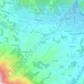
Name: Kurutxaldea topographic map, elevation, terrain.
Average elevation: 271 m
Minimum elevation: 145 m
Maximum elevation: 878 m
Other topographic maps
Click on a map to view its topography, its elevation and its terrain.
Lazkorborda
France > Nouvelle-Aquitaine > Pyrénées-Atlantiques > Anhaux
Lazkorborda, Anhaux, Bayonne, Pyrénées-Atlantiques, Nouvelle-Aquitaine, France métropolitaine, 64220, France
Average elevation: 339 m
Apheztegikoborda
France > Nouvelle-Aquitaine > Pyrénées-Atlantiques > Anhaux
Apheztegikoborda, Anhaux, Bayonne, Pyrénées-Atlantiques, Nouvelle-Aquitaine, France métropolitaine, 64220, France
Average elevation: 350 m