
Thank you for supporting this site ❤️
Make a donation
Make a donation
Fig Tree Pocket topographic map
Click on the map to display elevation.
Thank you for supporting this site ❤️
Make a donation
Make a donation
About this map
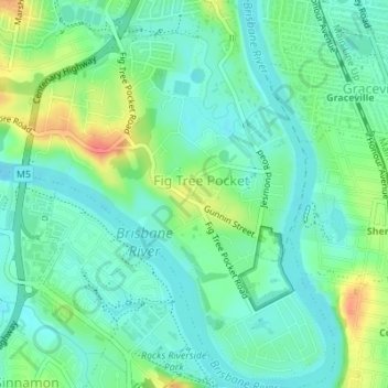
Name: Fig Tree Pocket topographic map, elevation, terrain.
Location: Fig Tree Pocket, Brisbane City, Queensland, Australia (-27.54447 152.94699 -27.51404 152.97450)
Average elevation: 20 m
Minimum elevation: 1 m
Maximum elevation: 63 m
Thank you for supporting this site ❤️
Make a donation
Make a donation
Other topographic maps
Click on a map to view its topography, its elevation and its terrain.