
Hähnichen topographic map
Interactive map
Click on the map to display elevation.
About this map
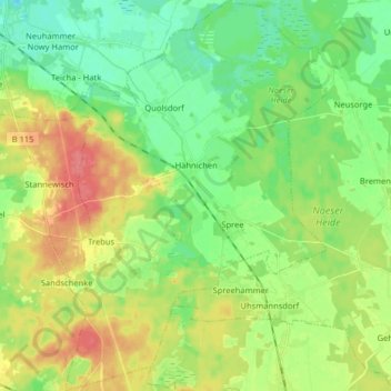
Name: Hähnichen topographic map, elevation, terrain.
Location: Hähnichen, Rothenburg/Oberlausitz, Görlitz, Saxony, Germany (51.30710 14.80425 51.40733 14.91809)
Average elevation: 161 m
Minimum elevation: 137 m
Maximum elevation: 197 m
Other topographic maps
Click on a map to view its topography, its elevation and its terrain.
02906
Germany > Saxony > Görlitz > Quitzdorf am See - Kwětanecy > Sproitz > Hintersproitz
02906, Hintersproitz, Sproitz, Quitzdorf am See - Kwětanecy, Diehsa, Görlitz, Saxony, Germany
Average elevation: 162 m