
Thank you for supporting this site ❤️
Make a donation
Make a donation
Marchin topographic map
Click on the map to display elevation.
Thank you for supporting this site ❤️
Make a donation
Make a donation
About this map
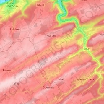
Name: Marchin topographic map, elevation, terrain.
Location: Marchin, Huy, Liège, Wallonia, 4570, Belgium (50.42707 5.19684 50.50778 5.28456)
Average elevation: 226 m
Minimum elevation: 70 m
Maximum elevation: 281 m
Thank you for supporting this site ❤️
Make a donation
Make a donation
Other topographic maps
Click on a map to view its topography, its elevation and its terrain.
Bassin de décantation des résidus miniers
Belgium > Liège > Huy > Wanze > Huccorgne > Le Taillis
Average elevation: 133 m
Thank you for supporting this site ❤️
Make a donation
Make a donation