
Thank you for supporting this site ❤️
Make a donation
Make a donation
Georgetown topographic map
Click on the map to display elevation.
Thank you for supporting this site ❤️
Make a donation
Make a donation
About this map
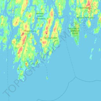
Name: Georgetown topographic map, elevation, terrain.
Location: Georgetown, Sagadahoc County, Maine, 04548, United States (43.65400 -69.78865 43.89354 -69.66475)
Average elevation: 8 m
Minimum elevation: -2 m
Maximum elevation: 83 m
Thank you for supporting this site ❤️
Make a donation
Make a donation
Other topographic maps
Click on a map to view its topography, its elevation and its terrain.