
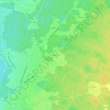
En Bergoin topographic map
Interactive map
Click on the map to display elevation.
About this map
Name: En Bergoin topographic map, elevation, terrain.
Average elevation: 28 m
Minimum elevation: 16 m
Maximum elevation: 39 m
Other topographic maps
Click on a map to view its topography, its elevation and its terrain.
Ispe
France > Nouvelle-Aquitaine > Landes > Biscarrosse
Ispe, Biscarrosse, Mont-de-Marsan, Landes, Nouvelle-Aquitaine, France métropolitaine, 40600, France
Average elevation: 30 m
Hautes-Rives
France > Nouvelle-Aquitaine > Landes > Biscarrosse
Hautes-Rives, Biscarrosse, Mont-de-Marsan, Landes, Nouvelle-Aquitaine, France métropolitaine, 40600, France
Average elevation: 31 m
La Broustasse
France > Nouvelle-Aquitaine > Landes > Biscarrosse
La Broustasse, Biscarrosse, Mont-de-Marsan, Landes, Nouvelle-Aquitaine, France métropolitaine, 40600, France
Average elevation: 28 m
Petit Étang de Biscarosse
France > Nouvelle-Aquitaine > Landes > Biscarrosse > Trappe
Petit Étang de Biscarosse, Trappe, Biscarrosse, Mont-de-Marsan, Landes, Nouvelle-Aquitaine, France métropolitaine, 40600, France
Average elevation: 24 m
Laouadie
France > Nouvelle-Aquitaine > Landes > Biscarrosse
Laouadie, Biscarrosse, Mont-de-Marsan, Landes, Nouvelle-Aquitaine, France métropolitaine, 40600, France
Average elevation: 26 m