
Make a donation
Ur topographic map
Click on the map to display elevation.
Make a donation
About this map
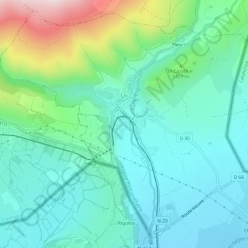
Name: Ur topographic map, elevation, terrain.
Average elevation: 1,259 m
Minimum elevation: 1,153 m
Maximum elevation: 1,593 m
Make a donation
Other topographic maps
Click on a map to view its topography, its elevation and its terrain.
Pic de Finestrelles
France > Occitania > Pyrénées-Orientales > Eyne
Pic de Finestrelles is a mountain located in the Oriental Pyrenees, on the border of France and Spain. It has an altitude of 2,826 metres (9,272 ft) above sea level.
Average elevation: 2,502 m
Pic de Finestrelles
France > Occitania > Pyrénées-Orientales > Eyne
Pic de Finestrelles is a mountain located in the Oriental Pyrenees, on the border of France and Spain. It has an altitude of 2,826 metres (9,272 ft) above sea level.
Average elevation: 2,502 m
Make a donation
Make a donation
La Ville
France > Occitania > Pyrénées-Orientales > Saint-Laurent-de-la-Salanque
Average elevation: 4 m
Make a donation
Station de Puyvalador
France > Occitania > Pyrénées-Orientales > Puyvalador
Average elevation: 1,768 m
Make a donation