
Thank you for supporting this site ❤️
Make a donation
Make a donation
Lozer topographic map
Click on the map to display elevation.
Thank you for supporting this site ❤️
Make a donation
Make a donation
Lozer
Lozer ligt in Zandlemig Vlaanderen op een hoogte van ongeveer 20 meter. Een belangrijk natuurgebied is het Lozerbos.
Thank you for supporting this site ❤️
Make a donation
Make a donation
About this map
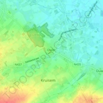
Name: Lozer topographic map, elevation, terrain.
Location: Lozer, Kruishoutem, Kruisem, Oudenaarde, Oost-Vlaanderen, België (50.90012 3.54960 50.93844 3.58825)
Average elevation: 21 m
Minimum elevation: 5 m
Maximum elevation: 54 m
Thank you for supporting this site ❤️
Make a donation
Make a donation
Other topographic maps
Click on a map to view its topography, its elevation and its terrain.