
Thank you for supporting this site ❤️
Make a donation
Make a donation
Salussola topographic map
Click on the map to display elevation.
Thank you for supporting this site ❤️
Make a donation
Make a donation
About this map
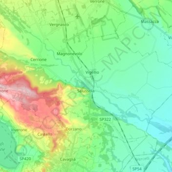
Name: Salussola topographic map, elevation, terrain.
Location: Salussola, Biella, Piedmont, 13885, Italy (45.41999 8.07182 45.48422 8.22054)
Average elevation: 266 m
Minimum elevation: 185 m
Maximum elevation: 475 m
Thank you for supporting this site ❤️
Make a donation
Make a donation
Other topographic maps
Click on a map to view its topography, its elevation and its terrain.
Thank you for supporting this site ❤️
Make a donation
Make a donation
Thank you for supporting this site ❤️
Make a donation
Make a donation
Thank you for supporting this site ❤️
Make a donation
Make a donation
Thank you for supporting this site ❤️
Make a donation
Make a donation
Thank you for supporting this site ❤️
Make a donation
Make a donation