
Thank you for supporting this site ❤️
Make a donation
Make a donation
Fridley topographic map
Click on the map to display elevation.
Thank you for supporting this site ❤️
Make a donation
Make a donation
About this map
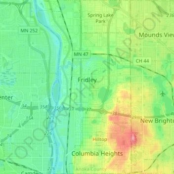
Name: Fridley topographic map, elevation, terrain.
Location: Fridley, Anoka County, Minnesota, United States (45.03549 -93.29609 45.12460 -93.22714)
Average elevation: 270 m
Minimum elevation: 243 m
Maximum elevation: 331 m
Thank you for supporting this site ❤️
Make a donation
Make a donation
Other topographic maps
Click on a map to view its topography, its elevation and its terrain.
Rum River North County Park
United States > Minnesota > Anoka County > Saint Francis
Average elevation: 279 m
Thank you for supporting this site ❤️
Make a donation
Make a donation