
Thank you for supporting this site ❤️
Make a donation
Make a donation
Frankfurt topographic map
Click on the map to display elevation.
Thank you for supporting this site ❤️
Make a donation
Make a donation
About this map
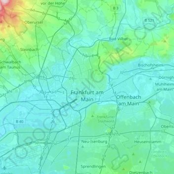
Name: Frankfurt topographic map, elevation, terrain.
Location: Frankfurt, Hesse, Germany (50.01535 8.47276 50.22714 8.80040)
Average elevation: 133 m
Minimum elevation: 90 m
Maximum elevation: 483 m
Thank you for supporting this site ❤️
Make a donation
Make a donation