
Saint-Constant topographic map
Interactive map
Click on the map to display elevation.
About this map
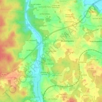
Name: Saint-Constant topographic map, elevation, terrain.
Average elevation: 103 m
Minimum elevation: 73 m
Maximum elevation: 128 m
La commune est occupée dans sa partie ouest par le plateau calcaire de la Braconne, appartenant au karst de La Rochefoucauld ; son altitude moyenne est de 120 mètres.
Other topographic maps
Click on a map to view its topography, its elevation and its terrain.
Rochepoule
France > Nouvelle-Aquitaine > Charente > La Rochefoucauld-en-Angoumois > Saint-Projet-Saint-Constant
Rochepoule, Saint-Projet-Saint-Constant, La Rochefoucauld-en-Angoumois, Angoulême, Charente, Nouvelle-Aquitaine, France métropolitaine, 16110, France
Average elevation: 98 m