
Make a donation
Zhejiang topographic map
Click on the map to display elevation.
Make a donation
Zhejiang
Zhejiang consists mostly of hills, which account for about 70% of its total area, with higher altitudes towards the south and the west. Zhejiang also has a longer coastline than any other mainland province of China. The Qiantang River runs through the province, from which it derives its name. Included in the province are three thousand islands, the most in China. The capital Hangzhou marks the end of the Grand Canal and lies on Hangzhou Bay on the north of Zhejiang, which separates Shanghai and Ningbo. The bay contains many small islands collectively called the Zhoushan Islands.
Make a donation
About this map
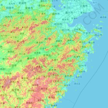
Name: Zhejiang topographic map, elevation, terrain.
Location: Zhejiang, China (26.85910 118.02241 31.18258 123.39362)
Average elevation: 223 m
Minimum elevation: -2 m
Maximum elevation: 2,037 m
Make a donation
Other topographic maps
Click on a map to view its topography, its elevation and its terrain.
Make a donation
Make a donation