
Thank you for supporting this site ❤️
Make a donation
Make a donation
Nidrum topographic map
Click on the map to display elevation.
Thank you for supporting this site ❤️
Make a donation
Make a donation
About this map
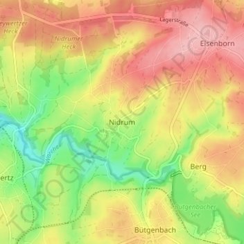
Name: Nidrum topographic map, elevation, terrain.
Location: Nidrum, Bütgenbach, Verviers, Liège, Wallonia, 4750, Belgium (50.42438 6.17682 50.46438 6.21682)
Average elevation: 574 m
Minimum elevation: 501 m
Maximum elevation: 634 m
Thank you for supporting this site ❤️
Make a donation
Make a donation