
Jackson topographic map
Click on the map to display elevation.
About this map
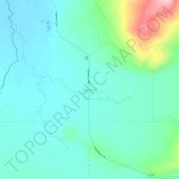
Name: Jackson topographic map, elevation, terrain.
Location: Jackson, Beaverhead County, Montana, 59736, United States (45.34813 -113.42908 45.38813 -113.38908)
Average elevation: 1,995 m
Minimum elevation: 1,952 m
Maximum elevation: 2,159 m
Other topographic maps
Click on a map to view its topography, its elevation and its terrain.
Dillon
United States > Montana > Beaverhead County
Dillon is located at 45°12′57″N 112°38′3″W / 45.21583°N 112.63417°W / 45.21583; -112.63417 (45.215735, -112.634055), approximately 40 miles (64 km) east of the Continental Divide. It lies at an elevation of 5,102 feet (1,555 m).
Average elevation: 1,562 m
Wisdom
United States > Montana > Beaverhead County > Wisdom
Wisdom is located at 45°36′58″N 113°26′59″W / 45.61611°N 113.44972°W / 45.61611; -113.44972 (45.616120, -113.449742). According to the United States Census Bureau, the CDP has a total area of 0.99 square miles (2.56 km2), of which 0.98 square miles (2.54 km2) is land and 0.0077 square…
Average elevation: 1,848 m
Dillon
United States > Montana > Beaverhead County
Dillon is located at 45°12′57″N 112°38′3″W / 45.21583°N 112.63417°W / 45.21583; -112.63417 (45.215735, -112.634055), approximately 40 miles (64 km) east of the Continental Divide. It lies at an elevation of 5,102 feet (1,555 m).
Average elevation: 1,562 m
Dillon
United States > Montana > Beaverhead County
Dillon is situated on the Beaverhead River. It lies at an elevation of 5,102 feet (1,555 m).
Average elevation: 1,562 m