
Portsmouth topographic map
Interactive map
Click on the map to display elevation.
About this map
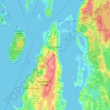
Name: Portsmouth topographic map, elevation, terrain.
Location: Portsmouth, Newport County, Rhode Island, United States (41.51563 -71.37305 41.66686 -71.21392)
Average elevation: 19 m
Minimum elevation: -4 m
Maximum elevation: 93 m
Other topographic maps
Click on a map to view its topography, its elevation and its terrain.
Aquidneck Island
United States > Rhode Island > Newport County > Portsmouth
Aquidneck Island, Portsmouth, Newport County, Rhode Island, United States
Average elevation: 13 m
Goat Island
United States > Rhode Island > Newport County > Newport
Goat Island, Newport, Newport County, Rhode Island, United States
Average elevation: 2 m
Tiverton
United States > Rhode Island > Newport County
Tiverton, Newport County, Rhode Island, 02878, United States
Average elevation: 31 m
Jamestown
United States > Rhode Island > Newport County
Jamestown, Newport County, Rhode Island, 02835, United States
Average elevation: 8 m
Middletown
United States > Rhode Island > Newport County
Middletown, Newport County, Rhode Island, 02842, United States
Average elevation: 19 m
Narragansett Bay
United States > Rhode Island > Newport County
Narragansett Bay, Newport County, Rhode Island, 02783, United States
Average elevation: 4 m
Little Compton
United States > Rhode Island > Newport County
Little Compton, Newport County, Rhode Island, United States
Average elevation: 9 m
Prudence Island
United States > Rhode Island > Newport County > Portsmouth
Prudence Island, Portsmouth, Newport County, Rhode Island, United States
Average elevation: 6 m
Newport
United States > Rhode Island > Newport County
Newport, Newport County, Rhode Island, 02840, United States
Average elevation: 8 m
Pottersville
United States > Rhode Island > Newport County > Little Compton > Pottersville
Pottersville, Little Compton, Newport County, Rhode Island, 02837, United States
Average elevation: 17 m