
Thank you for supporting this site ❤️
Make a donation
Make a donation
Ravenshead topographic map
Click on the map to display elevation.
Thank you for supporting this site ❤️
Make a donation
Make a donation
About this map
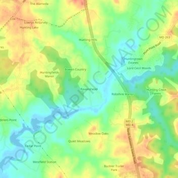
Name: Ravenshead topographic map, elevation, terrain.
Location: Ravenshead, Calvert County, Maryland, 20610, United States (38.56095 -76.63357 38.60095 -76.59357)
Average elevation: 22 m
Minimum elevation: -4 m
Maximum elevation: 47 m
Thank you for supporting this site ❤️
Make a donation
Make a donation
Other topographic maps
Click on a map to view its topography, its elevation and its terrain.
Thank you for supporting this site ❤️
Make a donation
Make a donation
Thank you for supporting this site ❤️
Make a donation
Make a donation