
Thank you for supporting this site ❤️
Make a donation
Make a donation
Fox Ridge State Park topographic map
Click on the map to display elevation.
Thank you for supporting this site ❤️
Make a donation
Make a donation
About this map
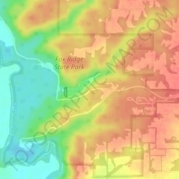
Name: Fox Ridge State Park topographic map, elevation, terrain.
Location: Fox Ridge State Park, Coles County, Illinois, United States (39.40332 -88.15315 39.40342 -88.15305)
Average elevation: 200 m
Minimum elevation: 164 m
Maximum elevation: 224 m
Thank you for supporting this site ❤️
Make a donation
Make a donation
Other topographic maps
Click on a map to view its topography, its elevation and its terrain.