
Bréchan topographic map
Interactive map
Click on the map to display elevation.
About this map
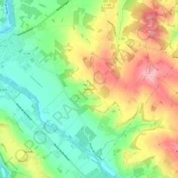
Name: Bréchan topographic map, elevation, terrain.
Average elevation: 102 m
Minimum elevation: 34 m
Maximum elevation: 188 m
Other topographic maps
Click on a map to view its topography, its elevation and its terrain.
Malé
France > Nouvelle-Aquitaine > Lot-et-Garonne > Nérac > Malé
Malé, Nérac, Lot-et-Garonne, Nouvelle-Aquitaine, France métropolitaine, 47600, France
Average elevation: 98 m
Cauderoue
France > Nouvelle-Aquitaine > Lot-et-Garonne > Nérac
Cauderoue, Nérac, Lot-et-Garonne, Nouvelle-Aquitaine, France métropolitaine, 47600, France
Average elevation: 87 m