
Thank you for supporting this site ❤️
Make a donation
Make a donation
Yichuan County topographic map
Click on the map to display elevation.
Thank you for supporting this site ❤️
Make a donation
Make a donation
About this map
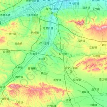
Name: Yichuan County topographic map, elevation, terrain.
Location: Yichuan County, Luoyang, Henan, China (34.21415 112.19956 34.54480 112.76886)
Average elevation: 335 m
Minimum elevation: 132 m
Maximum elevation: 972 m
Thank you for supporting this site ❤️
Make a donation
Make a donation
Other topographic maps
Click on a map to view its topography, its elevation and its terrain.