
Dawson City topographic map
Interactive map
Click on the map to display elevation.
About this map
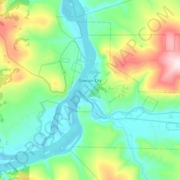
Name: Dawson City topographic map, elevation, terrain.
Location: Dawson City, Yukon, Y0B 1G0, Canada (64.02198 -139.48364 64.08953 -139.28144)
Average elevation: 507 m
Minimum elevation: 300 m
Maximum elevation: 1,061 m
Other topographic maps
Click on a map to view its topography, its elevation and its terrain.
Tombstone Territorial Park
Tombstone Territorial Park, Yukon, Y0B 1G0, Canada
Average elevation: 1,355 m
Yukon Crossing
Canada > Yukon > Yukon Crossing
Yukon Crossing, Yukon, Unorganized, Yukon, Canada
Average elevation: 663 m