
Thank you for supporting this site ❤️
Make a donation
Make a donation
Hoogste punt Vilvoorde topographic map
Click on the map to display elevation.
Thank you for supporting this site ❤️
Make a donation
Make a donation
About this map
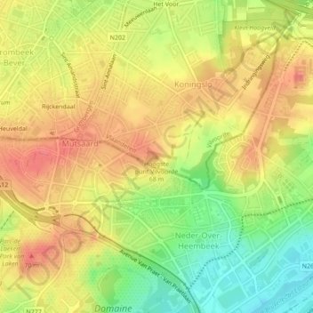
Name: Hoogste punt Vilvoorde topographic map, elevation, terrain.
Average elevation: 49 m
Minimum elevation: 10 m
Maximum elevation: 76 m
Thank you for supporting this site ❤️
Make a donation
Make a donation
Other topographic maps
Click on a map to view its topography, its elevation and its terrain.
Vilvoorde
België > Vlaams-Brabant > Halle-Vilvoorde > Vilvoorde
Het hoogtepunt van zijn bloei beleefde Vilvoorde in de 14de eeuw. De stad was een belangrijk centrum dat met Leuven en Brussel wedijverde om de belangrijkste stad van Brabant te worden. Uit deze periode dateren verschillende grote bouwwerken. In 1357 werd de stad helemaal omwald. Deze vesten hadden…
Average elevation: 24 m