
Makoshika State Park topographic map
Interactive map
Click on the map to display elevation.
About this map
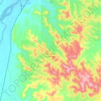
Name: Makoshika State Park topographic map, elevation, terrain.
Average elevation: 701 m
Minimum elevation: 625 m
Maximum elevation: 824 m
Other topographic maps
Click on a map to view its topography, its elevation and its terrain.
Makoshika State Park
United States > Montana > Dawson County > Glendive
Makoshika State Park, Glendive, Dawson County, Montana, United States
Average elevation: 698 m