
Thank you for supporting this site ❤️
Make a donation
Make a donation
Uusimaa topographic map
Click on the map to display elevation.
Thank you for supporting this site ❤️
Make a donation
Make a donation
About this map
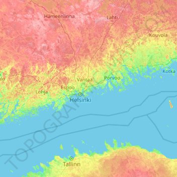
Name: Uusimaa topographic map, elevation, terrain.
Location: Uusimaa, Southern Finland, Mainland Finland, Finland (59.61100 22.65893 60.84085 26.65615)
Average elevation: 46 m
Minimum elevation: -3 m
Maximum elevation: 210 m
Thank you for supporting this site ❤️
Make a donation
Make a donation
Other topographic maps
Click on a map to view its topography, its elevation and its terrain.