
Make a donation
Hamburg topographic map
Click on the map to display elevation.
Make a donation
Hamburg
The neighbourhoods of Neuenfelde, Cranz, Francop and Finkenwerder are part of the Altes Land (old land) region, the largest contiguous fruit-producing region in Central Europe. Neugraben-Fischbek has Hamburg's highest elevation, the Hasselbrack at 116.2 metres (381 ft) AMSL. Hamburg borders the states of Schleswig-Holstein and Lower Saxony.
Make a donation
About this map
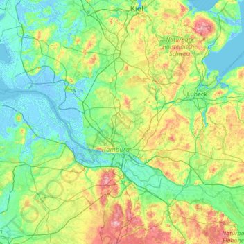
Name: Hamburg topographic map, elevation, terrain.
Location: Hamburg, Germany (53.39511 8.10450 54.02765 10.32528)
Average elevation: 27 m
Minimum elevation: -6 m
Maximum elevation: 157 m
Make a donation
Other topographic maps
Click on a map to view its topography, its elevation and its terrain.
Missen - Pšyne
Germany > Brandenburg > Oberspreewald-Lausitz - Górne Błota-Łužyca > Vetschau/Spreewald
Average elevation: 72 m
Make a donation
Wehr (Mosel)
Germany > Rhineland-Palatinate > Landkreis Trier-Saarburg > Palzem > Wehr (Mosel)
Average elevation: 201 m
Make a donation
Leichlingen
Germany > North Rhine-Westphalia > Rheinisch-Bergischer Kreis > Leichlingen > Leichlingen
Average elevation: 95 m