Geolocate

Kroaz Kermel topographic map

Interactive map

Click on the map to display elevation.

About this map

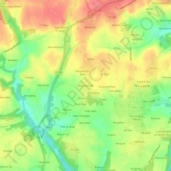
Name: Kroaz Kermel topographic map, elevation, terrain.

Location: Kroaz Kermel, Plomelin, Quimper, Finistère, Bretagne, France métropolitaine, 29700, France (47.92035 -4.19147 47.96035 -4.15147)

Average elevation: 56 m

Minimum elevation: 18 m

Maximum elevation: 88 m

Other topographic maps

Click on a map to view its topography, its elevation and its terrain.

Pennanguer Bihan

France > Bretagne > Finistère > Plomelin

Pennanguer Bihan, Plomelin, Quimper, Finistère, Bretagne, France métropolitaine, 29700, France

Average elevation: 48 m

Kerbiliès

France > Bretagne > Finistère > Plomelin

Kerbiliès, Plomelin, Quimper, Finistère, Bretagne, France métropolitaine, 29700, France

Average elevation: 27 m

Ty Lipic

France > Bretagne > Finistère > Plomelin > Ty Lipic

Ty Lipic, Plomelin, Quimper, Finistère, Bretagne, France métropolitaine, 29700, France

Average elevation: 65 m