
Thank you for supporting this site ❤️
Make a donation
Make a donation
Strehaia topographic map
Click on the map to display elevation.
Thank you for supporting this site ❤️
Make a donation
Make a donation
About this map
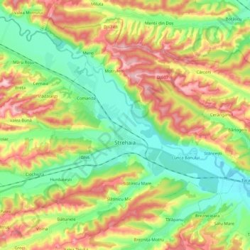
Name: Strehaia topographic map, elevation, terrain.
Location: Strehaia, Mehedinți, Romania (44.57091 23.08605 44.69528 23.28951)
Average elevation: 213 m
Minimum elevation: 120 m
Maximum elevation: 348 m
Thank you for supporting this site ❤️
Make a donation
Make a donation
Other topographic maps
Click on a map to view its topography, its elevation and its terrain.
Thank you for supporting this site ❤️
Make a donation
Make a donation
Thank you for supporting this site ❤️
Make a donation
Make a donation
Thank you for supporting this site ❤️
Make a donation
Make a donation