
Thank you for supporting this site ❤️
Make a donation
Make a donation
Temple Hill topographic map
Click on the map to display elevation.
Thank you for supporting this site ❤️
Make a donation
Make a donation
About this map
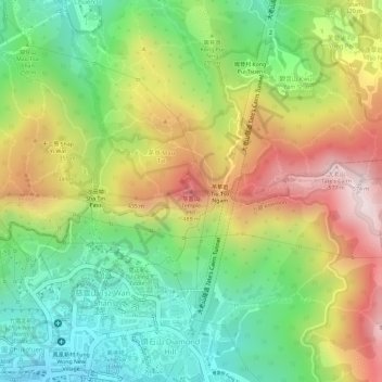
Name: Temple Hill topographic map, elevation, terrain.
Average elevation: 259 m
Minimum elevation: 19 m
Maximum elevation: 552 m
Thank you for supporting this site ❤️
Make a donation
Make a donation
Other topographic maps
Click on a map to view its topography, its elevation and its terrain.
Wu Kai Sha Beach
China > Hong Kong > Sha Tin District > Wu Kai Sha Village > Cheung Kang Village
Average elevation: 36 m