Geolocate

Dakabin topographic map

Interactive map

Click on the map to display elevation.

About this map

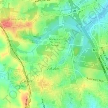
Name: Dakabin topographic map, elevation, terrain.

Location: Dakabin, Moreton Bay Regional, Queensland, Australia (-27.23488 152.96741 -27.21174 153.00332)

Average elevation: 36 m

Minimum elevation: 13 m

Maximum elevation: 65 m

Other topographic maps

Click on a map to view its topography, its elevation and its terrain.

Crystal Cascades

Australia > Queensland

Average elevation: 365 m

Gladstone

Australia > Queensland

Average elevation: 24 m

Bundaberg

Australia > Queensland > Bundaberg Region

Average elevation: 18 m

Peachester

Australia > Queensland > Peachester

Average elevation: 137 m

Proserpine

Australia > Queensland > Proserpine

Average elevation: 13 m

Townsville

Australia > Queensland > Townsville

Average elevation: 30 m

Rockhampton

Australia > Queensland > Rockhampton

Average elevation: 48 m

Gold Coast

Australia > Queensland > Gold Coast

Average elevation: 42 m