
Thank you for supporting this site ❤️
Make a donation
Make a donation
Hillsboro topographic map
Click on the map to display elevation.
Thank you for supporting this site ❤️
Make a donation
Make a donation
About this map
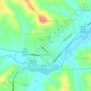
Name: Hillsboro topographic map, elevation, terrain.
Location: Hillsboro, Vernon County, Wisconsin, United States (43.64742 -90.35262 43.66239 -90.32236)
Average elevation: 307 m
Minimum elevation: 284 m
Maximum elevation: 368 m
Thank you for supporting this site ❤️
Make a donation
Make a donation
Other topographic maps
Click on a map to view its topography, its elevation and its terrain.
Wildcat Mountain State Park
United States > Wisconsin > Vernon County > Town of Whitestown
Average elevation: 310 m
Thank you for supporting this site ❤️
Make a donation
Make a donation
Wildcat Mountain State Park
United States > Wisconsin > Vernon County > Town of Whitestown
Average elevation: 310 m